

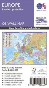
British Isles Communication

9
%
332 Kč 364 Kč
Odesíláme do 3 až 5 dní
Sleva až 70% u třetiny knih
This map shows the British isles, with all the major road, rail and sea connections. It is supplied rolled in a tube and is ideal for schools, students or just for decoration. It includes an index of place names. This map is gloss coated, so can be written on with suitable dry-wipe pens. It's scale is 1: 1 000 000
| Nakladatel: | Ordnance Survey |
| ISBN: | 9780319148440 |
| Rok vydání: | CZE |
| Jazyk : | Čeština |
| Vazba: | CZE |
Mohlo by se vám také líbit..
-

Dějepis 4 pro gymnázia a střední školy
Jan Kuklík
-

Zmizelá Šumava
Kintzl Emil, Fischer Jan
-

Oxford Maturita Excellence Z: Příprav...
E. Paulerová
-
Karty Kouzelné mapy
Colette Baron-Reid
-

Když draka bolí hlava
Petr Šiška
-

Přehledy českého jazyka 3.-5. ročník ...
Lenka Bradáčová
-

Silmarillion
J. R. R. Tolkien
-

Nalož to - Kujme pi(c)kle v kuchyni
Turecká Daniela
-

Padrino Krejčíř - Gangster
Kmenta Jaroslav
-

Bali a Lombok - Turistický průvodce
Kolektiv Autorů
-
Srí Lanka - Průvodce se samostatnou c...
neuveden
-

Slepá mapa
Alena Mornštajnová
-
Europe
-
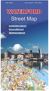
Waterford Street Map
-
Stonehaven & Banchory
-
OSNI 1:25000 Mournes Activity Includ...