



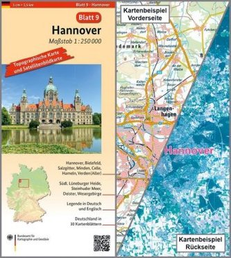
Topographische Karte und Satellitenbildkarte Hannover
11
%
171 Kč 192 Kč
Sleva až 70% u třetiny knih
Hannover, Blatt 9, ist Teil eines 30-teiligen Kartenwerks im Maßstab 1:250 000, mit dem Deutschland flächendeckend abdeckt wird.
Die topographische Landkarte Hannover zeigt die Region mit Bielefeld, Salzgitter, Minden, Celle, Hameln, Steinhuder Meer, Wesergebirge und südl. Lüneburger Heide.
Auf der Rückseite befindet sich eine Satellitenbildkarte (Sentinel-2 aus dem Copernicus Programm) mit dem Bereich entsprechend zur topographischen Karte.
Legende in Deutsch und Englisch.
| Nakladatel: | Bundesamt für Kartographie und Geodäsie |
| Rok vydání: | 2017 |
| Jazyk : | Němčina |
| Vazba: | Sheet map |
| Počet stran: | 2 |
Mohlo by se vám také líbit..
-

Project Fourth Edition 2 Pracovní seš...
Hutchinson, T.; Hardy-Gould, J.; Trnová,
-

Testy 2018 z českého jazyka pro žáky ...
-
Sbírka úloh z matematiky pro 4. a 5. ...
Michaela Kaslová
-

Raduga po novomu 1
neuveden
-

Project Fourth Edition 3 Pracovní seš...
Hutchinson, T.; Hardy-Gould, J.; Trnová,
-
Školní atlas dnešního Česka
-

Raduga po-novomu 2 - pracovní sešit
-

Project Fourth Edition 4 Workbook wit...
Hutchinson Tom
-

Matematikou krok za krokem k přijímac...
Petr Husar
-

Raduga po novomu 1
neuveden
-
Český jazyk
Jiří Melichar
-
Svět okolo nás, Prvouka pro 2. ročník ZŠ
Hana Rezutková; Marie Tichá
-
Landschaftskarte Deutschland 1 : 750 ...