



Topographische Karte und Satellitenbildkarte Köln
11
%
171 Kč 192 Kč
Sleva až 70% u třetiny knih
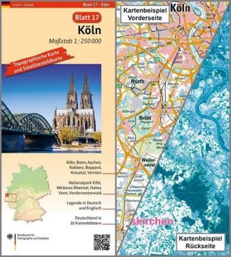
Köln, Blatt 17, ist Teil eines 30-teiligen Kartenwerks im Maßstab 1:250 000, mit dem Deutschland flächendeckend abdeckt wird.
Die topographische Landkarte Köln zeigt die Region mit Bonn, Aachen, Koblenz, Nationalpark Eifel, Mittleres Rheintal, Hohes Venn und Westerwald.
Auf der Rückseite befindet sich eine Satellitenbildkarte (Sentinel-2 aus dem Copernicus Programm) mit dem Bereich entsprechend zur topographischen Karte.
Legende in Deutsch und Englisch.
| Nakladatel: | Bundesamt für Kartographie und Geodäsie |
| Rok vydání: | 2017 |
| Jazyk : | ENG-GER |
| Vazba: | Sheet map |
| Počet stran: | 2 |
Mohlo by se vám také líbit..
-

FOREX – Ziskové intradenní a swingové...
Lien Kathy
-
Logistika pro manažery
Antonín Stehlík
-

Zásady ekonomie
N. Gregory Mankiw
-
Lídři jedí poslední
-
Hospodářská politika
Igor Kotlán; Christiana Kliková
-
Superguru Bárta
Kmenta Jaroslav
-

Vzestup peněz
Niall Ferguson
-
Základy ekonomie sportu
Vladimír Hobza
-
Oceňování nehmotných aktiv
-
Makroekonomie
Josef Brčák
-
Češi a Němci
Václav Makrlík
-

Restart
Jason Fried
-
Landschaftskarte Deutschland 1 : 750 ...