

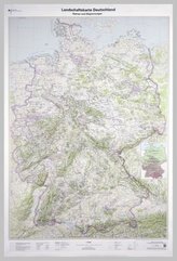
Topographische Karte und Satellitenbildkarte Leipzig

11
%
171 Kč 192 Kč
Sleva až 70% u třetiny knih
Leipzig, Blatt 15, ist Teil eines 30-teiligen Kartenwerks im Maßstab 1:250 000, mit dem Deutschland flächendeckend abdeckt wird.
Die topographische Landkarte Leipzig zeigt die Region mit Dresden, Dessau-Roßlau, Wittenberg, Lübbenau/Spreewald und Leipziger Tieflandsbucht.
Auf der Rückseite befindet sich eine Satellitenbildkarte (Sentinel-2 aus dem Copernicus Programm) mit dem Bereich entsprechend zur topographischen Karte.
Legende in Deutsch und Englisch.
| Nakladatel: | Bundesamt für Kartographie und Geodäsie |
| Rok vydání: | 2017 |
| Jazyk : | ENG-GER |
| Vazba: | Sheet map |
| Počet stran: | 2 |
Mohlo by se vám také líbit..
-

Pedagogika pro učitele
Alena Vališová
-

Logopedie
Jiřina Klenková
-

On-Line
Dewald, Wilfried
-
Maria Montessori
Standing, E. Mortimer
-

Maria Montessori
Böhm, Winfried
-

The Freedom Writers Diary
Gruwell, Erin
-

Kita-Kinder machen Theater
Kowolik, Bernadette
-

Mathe-Wissen auf einen Blick, Klasse ...
Boretzki, Anja
-
Mathe-Wissen auf einen Blick, Klasse ...
Boretzki, Anja
-

30 x Religion für 45 Minuten, Klasse 1/2
Kurt, Aline
-

Kinder entspannen mit Yoga
Proßowsky, Petra
-

Lingvodidaktické problémy výuky odbor...
Helena Hasilová
-
Landschaftskarte Deutschland 1 : 750 ...